 |
| Location of Fiji, in relation to Australia in the South Pacific Ocean. This location has significant meso-scale climate controls effecting it. Image: http://www.etravelblackboard.co.nz/article.asp?id=63145 |
As discussed in the previous blog, Fiji is also greatly influenced by the ITCZ, and more specifically the SPCZ. This is what causes the heavy rain season on the island. While the SPCZ resides over Fiji very large amounts of rain occur, during the Northern Hemisphere winter months (November to April), and when the ITCZ begins to move back to the North the rainfall begins to lessen.
Suva's micro-scale climate controls are greatly related to the topography of the island. The island has a mountainous center and causes a barrier for the East to West wind movement.
 |
| Map of Fiji showing the island of Viti Levu with Suva on the East side of the mountain range. Winds move East to West in the area and find the barrier of the mountains on the island. This has influences on the rainfall and storm development. Image: http://www.worldaccomodation.com/angol/continent/southpacific/fijiislands/vacationrentals.php |
The mountains, with Mt. Victoria being
the highest point, causes Orographic lifting to the air masses that move
over the area. This result in the majority of
the precipitation falling out of the air mass before it moves over
the range. As a result, Suva receives significantly more
rainfall than that of the West side of the island. About 117 inches a year
compared to cities in the West like Nadi which receives about 71 inches
of precipitation.
Data gathered from the Hong Kong
University
(http://www.hko.gov.hk/wxinfo/climat/world/eng/australia/pacific/nadi_e.htm)
Suva, though not being a large city,
still produces a small heat island from the impermeable surfaces and buildings
causing different energy balances than that of the natural environment. This
isn't nearly as noticeable as other cities because of the size and the
surrounding ocean.
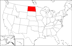
Contrary to the tropical island climate of Fiji, North Dakota is a land locked state in the U.S.A. This is nearly the polar opposite of Fiji sharing little to no similarities.
 |
| Location of North Dakota, residing in the North central of the United States. |
As we have seen Fiji is influenced by the ITCZ, whereas North Dakota is influenced by Polar air fronts. North Dakota is very far north and as a result can have long periods of dryness where as Suva receives moisture everyday. This is the result of the latitude of North Dakota, being far enough North to experience polar air masses dominating the area. On occasion a mid latitude cyclone can make it's way far enough North to deliver the moist maritime front to the polar front result in precipitation, but it doesn't occur very often. There are also Pacific fronts that occasionally come through. The result is cold dry winters.
On a micro-scale view we can see that North Dakota doesn't have much in the terms of elevation change. The mountain range in Suva causing the rain shadow in the West of the island is something that is unknown to North Dakota. It isn't Nebraska, but there are definitely no mountains. It would probably be to dry for the hills in the Southwest to create any rain shadow.
 |
| Southwest North Dakota in the Badlands area. The topography is pleasent to look at, but doesn't influence the climate in the same way that the mountains in Fiji do. Image: http://wikitravel.org/upload/en/thumb/8/82/Badlands1.jpg/250px-Badlands1.jpg |
 |
| The view of the mountains from Suva. Rarely is very clear to see the extent of how far they continue back. Considerably larger than North Dakota terrain. Image: http://mw2.google.com/mw-panoramio/photos/medium/69556144.jpg |


As a Fijian I am pretty impressed
ReplyDelete