Thursday, March 8, 2012

Weathering and Soil Types

Fiji as it is mostly know for is what everyone thinks about when they picture a tropical island (for the most part). The main island of Viti Levu has varying weathering that causes an assortment of outcomes. Being known as tropical the soil on the island is an oxisol which is the result of the process of laterization. The soil has a reddish color and the result of the soil containing iron and aluminum deposits in it.
A small pond in Suva, Fiji which has the red-orange hue from the oxisol soil's color.


Laterization causes the soil to be severely lacking in nutrients from leaching and the sheer amount of vegetation. Luckily Fiji has varying weather patterns on the island causing the soils to change. Calcification is how the soil of the non tropical parts forms. Sugar cane is grown in the East part of Viti Levu near Suva.

Sugar cane fields in Fiji with one recently burned to prepare for the next.


Viti Levu, the main island of Fiji, is big enough to have different climates on either side of the island. Wind carries storms from West to East. With the mountains residing in the middle of the island water is evaporating off of the ocean and the wind is moving to the West. The water condenses and is then dropped over the East part of the island which has the agriculture. Unfortunately, the water is almost always dropped on the East side of the mountains before it reaches the West. This causes the West part of the island, with cities like Nadi, to be very dry.
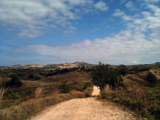
West side of Viti Levu showing the difference in climate.


The water cycle which causes the precipitation patterns on the island. The west of the island would be to the left of the mountains with most of the precipitation falling before it reaches that part of the island.


Sources:
Water: Personal


Monday, February 13, 2012

Volcanism of Viti Levu

Viti Levu is one of the largest Fiji islands. Being an archipelago we can assume that the islands must have come from some sort of volcanic activity. Fiji happens to lay between the Australian- Indian and the Pacific plate boundary. This subduction zone leads to not only Fiji being formed, but all of the islands in that part of the ocean. 
Image from  http://www.hsf.humanitus.org/images/articles/plates.jpg  
This island was formed much like the Andes Mountains except that it is an ocean plate subducting under another ocean plate. This creates heat as the two plates rub against each other creating enough heat to melt the rock causing it to rise to the surface. Several volcanoes began to form from these pockets of magma rising. Mt. Tomanivi, formally known as Mt. Victoria, is the volcano on Viti Levu. It is a shield volcano, but after being underwater several times and with land moving from tectonic forces it became a different shape.
Image from  http://www.nationaltrust.org.fj/wp/wp-content/themes/showtime/scripts/timthumb.php 


Viti Levu's land is rather weird for a ocean island. This is from the plate boundary. From the volcanoes there was basalt flooding, but there are also granite types of rock. This is from the plate boundary folding and warping the landscape. Considering the volcanoes haven't been active for many many years the landscape had to be changed in other ways. Earthquakes are still common here and continue to change the landscape. 
   
Image from  http://www.travelvivi.com/all-inclusive-resorts-fiji/