Thursday, December 6, 2012

Climate Controls and Temperature Changes Over Time

As most people know Fiji is a South Pacific volcanic island. This has effects on both the meso and micro-scale climate controls in the area.
Location of Fiji, in relation to Australia in the South Pacific Ocean. This location has significant meso-scale climate controls effecting it. Image: http://www.etravelblackboard.co.nz/article.asp?id=63145

Some of the greater meso-scale climate controls that have influence on Fiji are primary related to its location. Being a small island submits the area to have a climate that is at the will of the ocean surrounding it. Temperature fluctuations, as a result of seasonality, are barely noticeable. This is the result of the temperature being controlled by the surrounding waters. Water takes a very large amount of energy before it begins to gain sensible heat and it also doesn't lose it as easily, which is the opposite of how land reacts.
As discussed in the previous blog, Fiji is also greatly influenced by the ITCZ, and more specifically the SPCZ. This is what causes the heavy rain season on the island. While the SPCZ resides over Fiji very large amounts of rain occur, during the Northern Hemisphere winter months (November to April), and when the ITCZ begins to move back to the North the rainfall begins to lessen.

Suva's micro-scale climate controls are greatly related to the topography of the island. The island has a mountainous center and causes a barrier for the East to West wind movement. 
Map of Fiji showing the island of Viti Levu with Suva on the East side of the  mountain range. Winds move  East to West in the area and find the barrier of the mountains on the island. This has influences on the rainfall and storm development. Image: http://www.worldaccomodation.com/angol/continent/southpacific/fijiislands/vacationrentals.php
The mountains, with Mt. Victoria being the highest point, causes Orographic lifting to the air masses that move over the area. This result in the majority of the precipitation falling out of the air mass before it moves over the range. As a result, Suva receives significantly more rainfall than that of the West side of the island. About 117 inches a year compared to cities in the West like Nadi which receives about 71 inches of precipitation. 
Data gathered from the Hong Kong University
(http://www.hko.gov.hk/wxinfo/climat/world/eng/australia/pacific/nadi_e.htm)

Suva, though not being a large city, still produces a small heat island from the impermeable surfaces and buildings causing different energy balances than that of the natural environment. This isn't nearly as noticeable as other cities because of the size and the surrounding ocean. 
This is a graph of the average temperatures of July. A linear regression is added to each. From 1970 to 2012 there has been a slight increase in the average temperature. Only about a single degree centigrade. Data gathered from NOAA.

This is a graph of the average Temperatures of January. A linear regression was applied to both plots. From 1970 to 2012 January also showed an increase to overall temperature. The regressions so about 2.1 degree centigrade change for the maximum and a 1.5 degree centigrade change for the minimums.  Data gathered from NOAA.

From the graphs we can see a trending upward line. There could be a few factors resulting in this increase. It could be showing the overall climate change of the world increasing in temperature over this area. Or it could just be the result of micro-scale climate controls. Considering we can't really test to find out if this is the result of something like urban heat island or a warming trend in this area as the result of global climate change we can't make conclusions on it. We can just accept that there was a significant change of temperature in Suva from 1970 to now.


Contrary to the tropical island climate of Fiji, North Dakota is a land locked state in the U.S.A. This is nearly the polar opposite of Fiji sharing little to no similarities.
Location of North Dakota, residing in the North central of the United States.  
Being a land locked location with only a few sources of water around the state North Dakota is greatly influenced by seasonality. With the land gain and losing energy much more quickly than water, North Dakota has massive swings in temperature over the year. With highs around 85F in the summer, it is similar to Suva's highs, but through the transition to the winter, North Dakota drops to about 28F. The difference in temperatures being 57F compared to Suva's 10F degree fluctuations.
As we have seen Fiji is influenced by the ITCZ, whereas North Dakota is influenced by Polar air fronts. North Dakota is very far north and as a result can have long periods of dryness where as Suva receives moisture everyday. This is the result of the latitude of North Dakota, being far enough North to experience polar air masses dominating the area. On occasion a mid latitude cyclone can make it's way far enough North to deliver the moist maritime front to the polar front result in precipitation, but it doesn't occur very often. There are also Pacific fronts that occasionally come through. The result is cold dry winters. 
On a micro-scale view we can see that North Dakota doesn't have much in the terms of elevation change. The mountain range in Suva causing the rain shadow in the West of the island is something that is unknown to North Dakota. It isn't Nebraska, but there are definitely no mountains. It would probably be to dry for the hills in the Southwest to create any rain shadow.
File:Badlands1.jpg
Southwest North Dakota in the Badlands area. The topography is pleasent to look at, but doesn't influence the climate in the same way that the mountains in Fiji do. Image: http://wikitravel.org/upload/en/thumb/8/82/Badlands1.jpg/250px-Badlands1.jpg


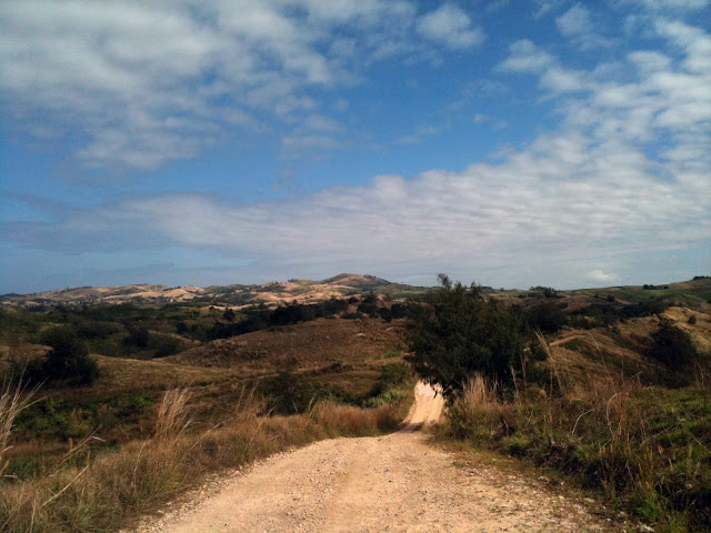
The view of the mountains from Suva. Rarely is very clear to see the extent of how far they continue back. Considerably larger than North Dakota terrain. Image: http://mw2.google.com/mw-panoramio/photos/medium/69556144.jpg


Friday, November 16, 2012

An Island in the South Pacific

Fiji being a South Pacific island doesn't have as many air mass influences as we have seen in Colorado. The island is East of Australia and Indonesia with Suva sitting at about 18 degrees South of the equator. This puts it in the prevailing winds of the Southeast Trades. This causes the air masses to be mT or maritime tropical over the entirety of the year. However, even though it is mT throughout the year there are other factors that effect the island that create significant changes in the weather showing up in seasonal weather patterns.
The general prevailing winds of the world. Sitting above the Tropic of Capricorn , you can see the East  to West winds of the Southeast Trades. Image : http://www.fccj.us/gly1001/tests/10Ch18L.htm
The Intertropical Convergence Zone (ITCZ) has great effect on Fiji. Residing in the South Pacific with little land to heat up and move the ITCZ results in a very significant affect on the weather of Fiji. It is known as the South Pacific Convergence Zone (SPCZ). It is a branch off the ITCZ. It has very little dependence on land heating and thus tends to stay in the same location year round. Convergence of the trade winds to the monsoon winds cause the convergence zone to form. 
The SPCZ over the Pacific Ocean in February. There is massive convergence over the islands in the South Pacific. This is  where Fiji resides and is what causes the seasonal weather that the islands face. Image: http://www.nrlmry.navy.mil/~chu/chap2img/fig204.jpg
This is the SPCZ during August over the Pacific Ocean. You can still see that it is still occurring, but is not as big. Image:  http://www.nrlmry.navy.mil/~chu/chap2img/fig204.jpg
From this we can see how the ITCZ effects Fiji. Large amounts of rainfall occur from November to April, and it tends to be dry from May to October. This coincides with the ITCZ. There are other things that determine the weather of the main island, Viti Levu, with the capital Suva on it. 
Being formed by volcanic processes the island is essentially a large mountain in the ocean. The ridge sits in the center of the island and causes localized weather on either side. Suva sits on the windward side of the mountain ridge and the storms also flow from East to West on the island. This causes large amounts of rain to fall on the East side of the mountain ridge causing it to be much more tropical, while the leeward side of the mountain ridge has a climate that is much dryer. This is very similar to what we experience in the lee of the Rockies. 
There may be very slight adiabatic heated winds on the lee side of the mountain ridge in Nadi, but they are probably less extreme than the Rockies. The highest point sits at 4340' so there is height for the air to heat up on the decent. Sitting in the SPCZ is unique, being the largest water convergence zone and it causes most of the weather in Fiji. 

This shows the SPCZ during the rainy months of the year. It passes right through the South Pacific and shows the convergence area. It shows the very low sea pressure areas. Storms form with this convergence.  Image: http://www.niwa.co.nz/sites/default/files/imported/__data/assets/image/0010/37945/olr_600.gif
These factors explain why Fiji experiences the weather it does. Being a volcanic island with a large mountain ridge residing in the middle, with mT air masses year round, and residing the area of the SPCZ, the weather and climate of Fiji is governed by these factors.

Tuesday, October 23, 2012

Average Temperature and Precipitation

With a country as small as Fiji and it's political problems it has faced over the years, data collection has been sparse until the military began being greatly influential in the countries politics. The station I will be examining is on the East side of the main island, Viti Levu, and is at the small airport in Suva. Regular data collection did not begin until 1988, but since the climate has remained similar for a great deal of time this did not affect the averages. The main island is formed from a volcano and as a result, it contains mountains splitting the island in  half. The airport is on the windward side of the mountains and from that, receives the brunt of the precipitation. The leeward side receives less precipitation from the rain shadow that the mountains create.
These are some visuals for the average month temperature and average monthly precipitation at the station.
Map of the main island of Fiji. On the East side you can see where Suva sits. This is where the weather station resides. 
Graph of average temperatures in Suva airport from 1988-2012. Data gathered from the NCDC. Being surrounded by the Pacific Ocean provides similar temperatures throughout the year. Data shows a ten degree temperature difference between the highs and the lows.

Graph of rainfall in inches per month from 1988- 2012. Data gathered from the NCDC. This shows that the dry season, respectively, occurs during the winter months along with the lowest temperatures.
Viti Levu, the main island, is like a lot of other volcanic island locations where it contains several different climates. The mountains from the volcano are not as great as the mountains we know, but are still significant. The island also contains tropical climates inland on the windward side of the island. Being an island it has coastal properties as well. From the rain shadow the West side of the island is significantly drier and has similar weather to the Midwest US. Suva, the city, would mostly be considered coastal tropical.

The Bowen Ratio for Suva would probably be around 1-3. This is because of the amount of water that evaporates in Suva. The amount of latent heat flux is near the amount of sensible heat. Fiji is a maritime location.


Thursday, May 3, 2012

Fiji Here to Stay?

Fiji is a group of islands in the southwest part of the Pacific Ocean with other places such as Vanuatu, Kiribati, and the Marshall Islands. Volcanic activity was the process in which allowed Fiji to appear above sea level. Fiji  lays on a portion of space between the Pacific and the Australian plate which is believed itself to be a plate called the Fiji plate. The Australian and Pacific plate subduct under the Fiji plate creating the unique islands.
Image depicting the locations of the Pacific and Australian plates to the Fiji plate.
The plate boundaries are still hard to explain, but it was, at a time, subducting from both sides.


The subduction zones added a situation in which volcanoes would form. The friction down the plates would heat up the rock melting it and it would rise as a result of being liquid and being very hot. The volcanoes built up the hundreds of islands in the South Pacific and left the notable Mt. Victoria which created Fiji's largest island Viti Levu.
Mt. Victoria which is now an inactive volcano was what created the island with its eruptions adding lava
to the surface of the earth.
With Viti Levu's location being in the South Pacific it is no surprise that the island is tropical with a monsoon. The monsoon brings rain through April to November. Trade winds blow the monsoon season storms East to West across the island. With the mountains in the middle of the island a significant rain shadow occurs dropping water on the East side of the island and less on the West side.
Windward side of Fiji with lush tropical jungles.
Leeward side of Fiji with much dryer conditions.
However, this perfect island will probably come to an end. Tropical cyclones happen every year and normally bring flooding to the area. This repeated flooding  will slowly begin to cause the island to have mass wasting events that will take down the island out to sea, of course of a great deal of time. The island, however, will probably meet it's fate through tectonics. The area is very active in movement which eventually causes earthquakes. 
These earthquakes, which also occur often, can have a few varying effects on the island. The island can be physically distorted from the actual movement of rocks, but something greater probably would occur. Being on active plate boundaries the risk of earthquakes reawakening dormant volcanoes is always there. If a volcano erupted the landscape would be greatly changed. The volcanoes are mostly andesite and would probably be explosive. This would cause ash and hot pyroclastic flows to burn the landscape killing vegetation. 


Example of a pyroclastic flow occurring at the Unzen Volcano.

Another potential result from an earthquake would be a tsunami occurring afterwords. Tsunamis happen along subducting plates from tension building up and then releasing creating a massive surge of water. With a tsunami the island could have a completely new makeover. Most of Viti Levu's cities are on the coast and a large tsunami would cause massive destruction along the coasts. This would rewrite what many of the low laying areas look like causing large amounts of change from the surge of water. 
Map of the rivers of Viti Levu which will eventually erode the land around them down until they have taken all of the land down to the ocean flattening the island in thousands of years.
Of course long term weathering will also slowly tear the land down. With the islands 54 rivers soil will be taken down stream out to the ocean until the land is flat. I believe that a new eruption from a volcano will not let that happen though. 
Sources:
Youtube

http://www.justpacific.com/fiji/fijiphotos/wrightpics/scenery/nabui.jpg
http://www.fiji.pictures-pacific.com/travel/pictures/03-viti-levu.jpg
http://whatonearth.olehnielsen.dk/plates/fiji.asp
http://en.wikipedia.org/wiki/Category:Rivers_of_Viti_Levu
http://joetourist.ca/fiji/graphics/VitiLevuMap.png

Wednesday, April 11, 2012

Climate and Weather

Fiji is classified as a tropical island that has a wet and dry season. Using Köeppen's climate classification Am describing a tropical monsoon. Between May and October is the dry season with steady weather in the 80's. The wet season between November and April will bring rain most of the time.
Rainfall during the wet season on Viti Levu.


Trade winds that run from the east across the island which draws water from the Pacific Ocean and then takes the water east to west across the island causing the east to get more rain and have more weather than the west. 
Canefields - Western Side of Viti Levu Fiji
West side of Viti Levu which looks a lot like the midwest US.

The west side gets significantly less rainfall as a result of the mountain range in the center of the island slowing up the movement of the storms carrying rainfall across the island. The precipitation mostly falls before it reaches the mountains leaving nothing to fall along the west side. The extra rain allows for much larger vegetation on the east side making it much more tropical.
East coast of Viti Levu with much larger vegetation of tress.


Being in the middle of the ocean near the equator Fiji has seasonal cyclones. The largest problem Fiji faces with cyclones are the resulting storm surges. Water rises flooding and causing the most damage to the city. 
Resulting from a storm surge the city cannot drain the water.


Sources:
travelblog.org
http://blog.travelpod.com/travel-photo/lewnwdc/11/1315103127/east-side-of-pago-pago-harbor.jpg/tpod.html
http://fijiphotos.net/geo_viti_levu.php


Thursday, March 8, 2012

Weathering and Soil Types

Fiji as it is mostly know for is what everyone thinks about when they picture a tropical island (for the most part). The main island of Viti Levu has varying weathering that causes an assortment of outcomes. Being known as tropical the soil on the island is an oxisol which is the result of the process of laterization. The soil has a reddish color and the result of the soil containing iron and aluminum deposits in it.
A small pond in Suva, Fiji which has the red-orange hue from the oxisol soil's color.


Laterization causes the soil to be severely lacking in nutrients from leaching and the sheer amount of vegetation. Luckily Fiji has varying weather patterns on the island causing the soils to change. Calcification is how the soil of the non tropical parts forms. Sugar cane is grown in the East part of Viti Levu near Suva.

Sugar cane fields in Fiji with one recently burned to prepare for the next.


Viti Levu, the main island of Fiji, is big enough to have different climates on either side of the island. Wind carries storms from West to East. With the mountains residing in the middle of the island water is evaporating off of the ocean and the wind is moving to the West. The water condenses and is then dropped over the East part of the island which has the agriculture. Unfortunately, the water is almost always dropped on the East side of the mountains before it reaches the West. This causes the West part of the island, with cities like Nadi, to be very dry.
West side of Viti Levu showing the difference in climate.


The water cycle which causes the precipitation patterns on the island. The west of the island would be to the left of the mountains with most of the precipitation falling before it reaches that part of the island.


Sources:
Water: Personal


Monday, February 13, 2012

Volcanism of Viti Levu

Viti Levu is one of the largest Fiji islands. Being an archipelago we can assume that the islands must have come from some sort of volcanic activity. Fiji happens to lay between the Australian- Indian and the Pacific plate boundary. This subduction zone leads to not only Fiji being formed, but all of the islands in that part of the ocean. 
Image from  http://www.hsf.humanitus.org/images/articles/plates.jpg  
This island was formed much like the Andes Mountains except that it is an ocean plate subducting under another ocean plate. This creates heat as the two plates rub against each other creating enough heat to melt the rock causing it to rise to the surface. Several volcanoes began to form from these pockets of magma rising. Mt. Tomanivi, formally known as Mt. Victoria, is the volcano on Viti Levu. It is a shield volcano, but after being underwater several times and with land moving from tectonic forces it became a different shape.
Image from  http://www.nationaltrust.org.fj/wp/wp-content/themes/showtime/scripts/timthumb.php 


Viti Levu's land is rather weird for a ocean island. This is from the plate boundary. From the volcanoes there was basalt flooding, but there are also granite types of rock. This is from the plate boundary folding and warping the landscape. Considering the volcanoes haven't been active for many many years the landscape had to be changed in other ways. Earthquakes are still common here and continue to change the landscape. 
   
Image from  http://www.travelvivi.com/all-inclusive-resorts-fiji/


Wednesday, January 25, 2012

Nice to meet you

Hello, I am Chad Bridges and this is my blog. The place that I am going to explore over this semester is  one of the main islands in Fiji, Viti Levu, but more specifically, the capital of Fiji Suva and Mt. Victoria.


I chose this location mainly because I have friends who live there. I specified Suva because it happens to be not as hot, and Fiji is burning hot, than the city on the other side of the island Nadi. Fiji also as many physical attributes that I do not experience here in Colorado. Using the form and processes in class I will attempt to analyze this beautiful country and fool myself in thinking I have been there and from that exploration, I might gain a understanding in physical geography. Now my journey begins.